Suitability for Infill Development: A Multi-criteria and Spatial Assessment Approach

This paper reviews an empirical case study application (Zapata County, Texas) of GIS tools in the assessment of the suitability of vacant sites for infill. Infill development refers to new development of vacant and under-utilized parcels within the built-up areas of existing communities that have in-place infrastructures.
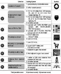
The inquiry includes a review of relevant studies and applications of GIS in sustainable urban planning, the creation of a code system for developable sites through the evaluation of eligible parcels in accordance with eight criteria, and a summing up of parcels’ composite scores. The method of intertwining GIS mapping with a coding and ranking system for developable sites was the most appropriate method for processing and projecting quantitatively and visually the big data necessary for this type of analysis and for combining this array of location-based attributes with the planning standards of smart growth. It also provided a useful tool that could be applied to large amounts of parcel data and be used to create visual mapping outputs for other communities and city center developments.
keywords: multi-criteria assessment, infill development, spatial analysis, site suitability


Add comment
Log in to post comments